First Alert Forecast: Rollercoaster week ahead
[anvplayer video=”5089300″ station=”998131″]
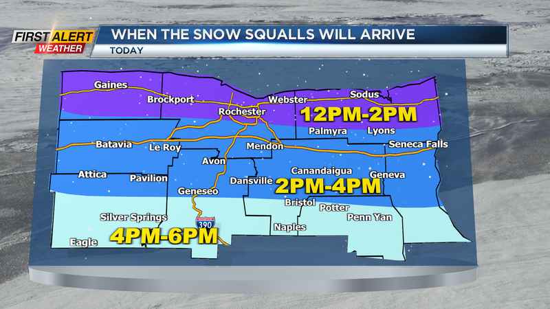
ROCHESTER, N.Y. (WHEC) – Lake effect snow this morning will continue into the afternoon hours today.
The best chance for lake effect snow will be along the immediate shoreline of Lake Ontario. Snow today will limit visibility at times and create slick roadways as afternoon highs remain in the mid teens. Lake effect snow will give us a bit of a break late this afternoon before setting up again along the lakeshore tonight and into Monday morning.
The morning commute for Rochester eastward may be a bit slick tomorrow morning before lake snow ends by the afternoon. When it is all said and done, folks north of the thruway could see 1"-3" of snow with localized areas right along the lakeshore having the best chance to see near 5". Areas south of the thruway and into the Finger Lakes will likely see an occasional snow shower or two, but less than an inch is expected.
We will remain on the cold side today, through Valentines Day, and into Tuesday before warmer weather arrives Wednesday. Most of the early part of the week will be dry and by Wednesday highs make their way into the upper 40s with some areas in the 50s! However, as we head into Thursday of this week our next bigger weather maker will approach from the west.
As of this morning, we are still on the milder side of things with rain as models have trended back towards the north. This will be monitored as the overall trend the past few days has been colder and south with the exception of this mornings model runs. We will monitor this to see if it is a sign of a northern trend, or a hiccup towards southern trends later today.
Regardless, we still have a chance for winter weather to fall locally, but we are also watching our for the milder side of things. We still have a decent snow pack across the region, and many of our waterways are still ice covered. Also, modeling is signaling a chance we’ll see near or over an inch of rain to fall locally if we end up on the milder side. This is of concern because we have a liquid equivalent of about .5" and an inch of water on the ground in the form of snow and if this were to melt off rapidly with an additional inch of rain falling we may have some flooding concerns along creeks and streams. Not of major concern as of now, but it will be something to monitor as low pressure track becomes solidified over the coming days.
To stay up to date with the latest trends, follow along with the First Alert Weather Team through this week.
And download the First Alert Weather App to keep you safe while you’re out and about.