First Alert Weather: A little snow, and a big warmup on the way
[anvplayer video=”5089545″ station=”998131″]
ROCHESTER, N.Y. (WHEC) — We’re finally saying goodbye to the persistent lake effect that has plagued us this weekend into Valentine’s Day.
The one spot that’ll see a little more snow will be east of Rochester, into parts of Wayne County. The wind will continue to direct some lake effect off of Lake Ontario there, with a few more inches of fluff tonight into Tuesday morning, before ending. A Winter Weather Advisory is posted for Wayne County Monday night through 1 p.m. Tuesday.
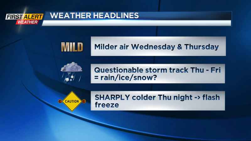
Outside of this, expect a partly cloudy sky and another chilly night. Some spots may briefly dip into the single digits tonight. A weak wind shift will push some lake effect over the Rochester region Tuesday morning. While we’ll see some flakes returning once again, expect less than a half-inch of additional accumulation for the majority of the area. Wednesday looks great! We’ll see some sun and milder air as highs reach well into the 40s. But, a busy wind will cut back on how warm it’ll actually feel.
Watching the end of the week: We’re still watching our next winter storm, set to take aim at our area by Thursday into Friday. We expect this to be a moderate impact storm, but uncertainty remains as to what kind of precipitation we’ll see. We initially start off on the milder side of the storm, bringing in 50s and rain on Thursday. The main question is how quickly does the colder air move in, and thus how quickly does rain change over to an icy mix or snow.
Something we are more certain about is temperatures plunging from the 50s into the 20s within a matter of hours Thursday night into Friday morning. This means we have a fairly high likelihood of seeing a flash freeze, and icy roads and sidewalks Friday morning. In the warmer scenario, most precipitation falls as rain, with a minor accumulation of snow by Friday morning. If the low takes a slightly more southerly track, we’ll still feel milder air and rain on Thursday, but the transition over to ice and snow will happen faster, meaning more snow accumulation by Friday morning.
[News10NBC]
A Yellow Alert may be needed for the combination of accumulating snow and a little sleet/ice, plus that flash freeze. The First Alert Weather Team is monitoring the track of the storm closely and will provide frequent updates over the next 24-48 hours as we get closer to the end of the week.
The weekend starts off chilly with some snow showers on Saturday along with a gusty wind, followed by quieter weather next Sunday.
—————————————
Download the WHEC First Alert Weather app to stay up to date while on the go.
Watch the latest full forecast at whec.com/weather.