First Alert Weather: Brief break from the heat Friday
[News10NBC]
ROCHESTER, N.Y. (WHEC) — A cold front knocking on our door tonight will bring us a little bit of relief from the recent heat & humidity, but it’ll be brief. That cold front may bring us a few showers or thunder overnight as it slowly settles through the area.
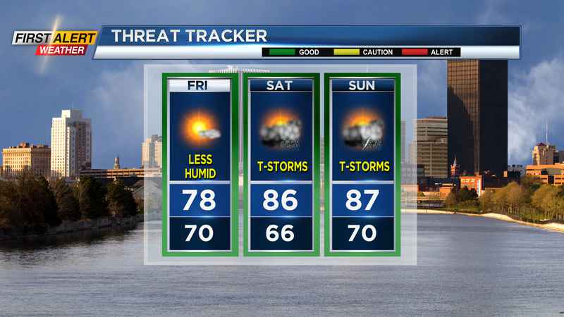
Friday starts off muggy and mild as the dew point slowly drops through the area. The front will tend to get caught up in the Southern Tier and Finger Lakes. This is where we’ll see the best chance for some scattered showers or storms, while areas closer to Rochester and Lake Ontario should stay mostly dry with a bit more sun. Humidity will slowly drop through the day, but remaining muggy further south. In all, the further north you are on Friday, the more comfortable and brighter it’ll be.
The weekend: The break from the humidity will be short-lived, as a warm front lifts back through the region on Saturday. This will bring a return to higher humidity and temperatures in the mid-80s. This will also bring scattered showers and storms to Western New York on both Saturday and Sunday. Neither day will be a washout, but you’ll likely have to adjust outdoor plans, depending on the timing. At this point, Saturday may start dry, and see some wet weather by afternoon.
Another cold front will move through on Monday, bringing another round of scattered storms. This front will push south Monday evening, providing cooler and more comfortable air for much of next week. The one thing we’ll be keeping an eye on is what will likely become Tropical Storm and then Hurricane Ida, which will impact the Gulf Coast. This may bring some tropical moisture northward by the middle of next week, but at this point, our forecast remains dry. Stay tuned for any updates.
____________________
Download the WHEC First Alert Weather app to stay up to date while on the go.
Watch the latest full forecast at whec.com/weather.