First Alert Weather: Henri brings flooding rain & damaging wind, a few showers locally
[News10 NBC]
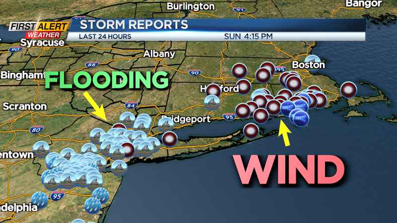
ROCHESTER, N.Y. (WHEC) — Tropical Storm Henri continues to weaken Sunday evening as it moved ashore in the Northeast. It brought impressive, flooding rain to the New York City area and damaging wind gusts to parts of New England.
Meanwhile, we’re feeling the tropical moisture here in western New York with lots of humidity. We’ll see some showers overnight and Monday as that tropical moisture continues to feed into our area. Some thunder is possible, and there may be some locally heavy rain in any storm. That being said, storms should have decent movement, and flooding shouldn’t be a major concern Monday.
Henri pulls away by Tuesday, leaving us with warm, dry air, and less humidity at least briefly.
Wednesday will turn more humid again, and that may help to pop a few afternoon showers. Most of the day Wednesday should be dry.
A weak front will try to drop south on Thursday with a slightly better chance of some showers or thunder followed by drier and cooler air (briefly) for Friday.
Next weekend may be the end of our sultry summery air with highs in the 80s and high humidity.
There are some signs that a pattern change will arrive for the last few days of August.
As far as temperatures go, we’ll stay on the warm side. Highs will flirt with 90 by Wednesday, then take a brief step back later in the week before warming back into the mid-80s by next weekend.
——
Download the WHEC First Alert Weather app to stay up to date while on the go.
Watch the latest full forecast at whec.com/weather.