First Alert Weather In-Depth: Warm front severe weather
[anvplayer video=”5115743″ station=”998131″]
ROCHESTER, N.Y. (WHEC) – We see the potential for severe weather over the next 24 to 36 hours and it is really due to a multitude of weather fronts that will be moving across Western New York.
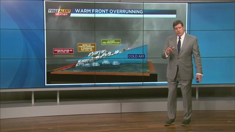
But let’s focus on just one of those fronts and that would be a warm front. That warm front is already on our doorstep. The best way to dissect this front is in a three-dimensional view. There is a lot of warm air that is streaming in from the Ohio valley and that steamy air is pushing in over the top of some of the cooler air. As a result, the warm air is being forced upwards. We call that overrunning and that lifting of air happens very quickly. Think of it like a hot air balloon and as it begins to rise it just keeps going upward.
Between a cold front and a warm front, a warm front is usually the gentler of the two frontal boundaries. However, is this case there is so much heat and so much moisture that we will see even more of these showers and thunderstorms breaking out across Western New York.
That will be happening later tonight. So the severe weather ingredients are pretty substantial. Instability is the first element that is going to be running very high. Wind shear is the difference between wind direction and wind speed as we increase in height. Right now that is rather low, but will be increasing tomorrow. An element we call forcing – that is the trigger to get everything going – that is at a moderate level.
When you sum it all up, the threat level is at the News 10NBC yellow alert.
It is also important to remember the difference between a weather watch and a weather warning. A watch means there is the potential or the ingredients of getting some severe weather. A warning means it is imminent or it is actually happening. So one way to remember this terminology is to say we are “watching for the warning.”