First Alert Weather: No need for the air conditioning
[anvplayer video=”5113555″ station=”998131″]
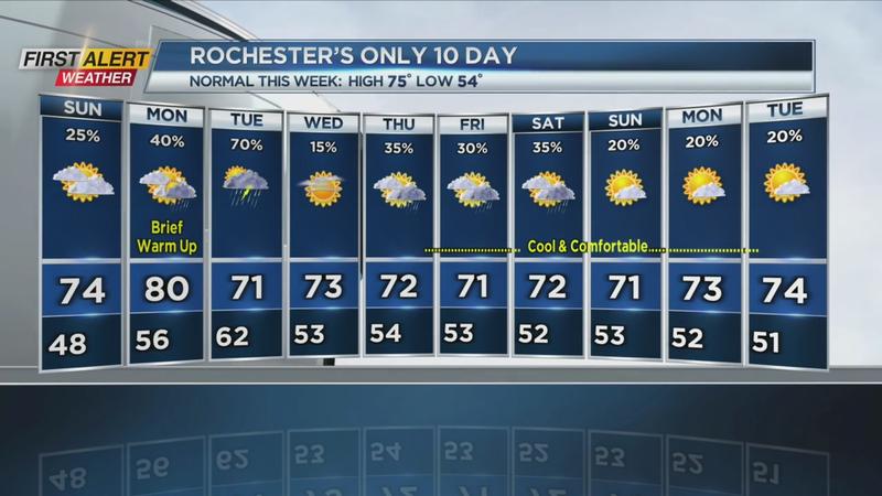
ROCHESTER, N.Y (WHEC) – We had all the ingredients for a comfortable day in Western New York. Plenty of sunshine, very low humidity and cooler than normal temperatures. In fact, it was the coolest day in almost two weeks. High pressure with a brisk northwesterly wind flow kept the normally warmer June temperatures away from Rochester today. That high-pressure system will largely stay in place tonight and early Sunday, before a warm front approaches by the end of the weekend.
Tonight expect mainly clear, starlit skies overhead for the balance of the night. But it will turn very cool with the low temperature in the upper 40s and remaining in the lower 50s near Lake Ontario. Sunday will bring partial sunshine for the morning then clouds will slowly increase for the afternoon. It will be another day of lower humidity with the high temperature near 73 degrees. Sunday evening there is the chance of a few scattered light rain showers developing. The low temperature in the middle 50s.
The News 10 NBC First Alert meteorologists expect a more unsettled weather pattern for the first half of the week. There will be an increasing probability of showers and thundershowers for Monday, Monday night and Tuesday with the highest probability of rain coming on Tuesday. The temperature will be near 80 degrees on Monday with the temperature sliding back into the lower 70s by Tuesday. Sunshine returns by Wednesday with the high temperature in the mid-70s.
Looking at the extended period for the next 6 to 10 days, we do not see any signs of the heat and humidity returning to Western New York.
Stay tuned to News 10NBC First Alert for forecast updates.
Download the WHEC First Alert Weather app to stay up to date while on the go.