First Alert Weather: Scattered showers tonight, cool air Friday
[News10NBC]
ROCHESTER, N.Y. (WHEC) — The main area of rain from Thursday is long gone, but a cold front will allow cooler air to pour in aloft.
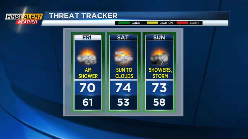
This will bring scattered showers, and even lake-enhanced rain showers overnight into early Friday morning. Friday will start in the lower 60s, and only make it into the upper 60s to near 70, thanks to cooler air battling against the strong July sun. Still, we’ll see a nicer afternoon with some nice sun returning, and drier air.
The weekend will be split. If you’re planning outdoor events, Saturday will be your better day with dry weather and a good deal of sun. We’ll start Saturday cool, in the lower 50s, but make our way back into the lower to mid-70s, which is still cool for late July, but comfortable. More clouds will fill in during the afternoon and evening, but any rain should hold off until around sunset. Showers will continue into Sunday, with the chance for a few afternoon storms, as a cold front slides through. Highs on Sunday will also hold in the low to mid-70s, but we’ll lack the nice sun and dry weather from Saturday.
Decent week ahead: We’ll start next week a little cool, with highs holding in the lower 70s on Monday, but a good deal of sun returning once again. Tuesday should warm into the mid-70s, with signs that we may try to flirt with 80 again by the end of the week. Overall, it’ll be a cooler than average week, but in the middle of summer, that generally means mild and comfortable temperatures. We’ll also see a mainly dry week, with just a few pop-up showers mid to late week.
——————————
Download the WHEC First Alert Weather app to stay up to date while on the go.
Watch the latest full forecast at whec.com/weather.