First Alert Weather: Warmer, drier Thursday
[News10NBC]
ROCHESTER, N.Y. (WHEC) — We’ve recorded rain almost every single day so far this month, but we see an end to this soggy pattern.
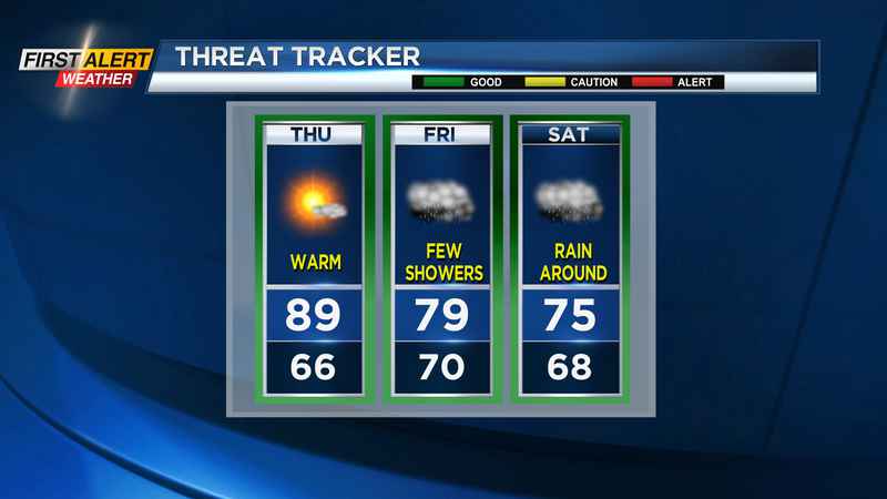
Any showers/thunder from Wednesday evening will end, leaving us with a partly cloudy to mainly clear sky overnight. It’ll be another muggy and mild night, with lows dropping into the mid to upper 60s. Thursday should be a mainly dry day, with the best chance for any rain coming late in the evening with a dying line of storms moving toward us. Thursday is your day to get in the yard, mow the lawn or have lunch outside. It’ll also be a toasty day, with highs up near 90.
Another round of rain moves in on Friday, as another stationary front sets up over WNY. This will bring clouds back in, and a return to shower weather. The best chance of thunder on Friday will likely be in the Finger Lakes and Southern Tier, where warmer air will lie. A slug of moisture moves in Friday night into Saturday, bringing us a wet start to the weekend. Again, the best chance of thunder will be south of the boundary. In fact, there are some indications that Saturday may end up cool, struggling to make it out of the 60s. For now, we’ll keep us in the 70s.
The good news is we should see a nicer end to the weekend, with highs back in the 80s with some sun, and drier weather. That dry weather will likely last into at least the start of next week, with highs a few degrees above average, and just a stray shower. Another front will try to work in by the middle of next week, but big moisture doesn’t look like it’ll be a concern.
——————————————————
Download the WHEC First Alert Weather app to stay up to date while on the go.
Watch the latest full forecast at whec.com/weather.