First Alert Weather: Changeable temperatures for the last few days of September
[News10NBC]
ROCHESTER, N.Y. (WHEC)— It was a little breezy Sunday as winds were gusting to near 30 mph. However, all things considered, it was a pleasant day for Western New York and this will lead to a decent Sunday evening.
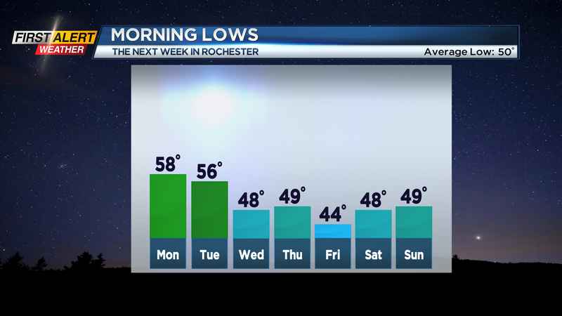
It will be dry early, but clouds will be on the increase with a few spotty showers well after midnight. The low temperature will be in the upper 50s and the temperature will begin to rise later Sunday night. That rising temperature will be an indicator of warmer weather for tomorrow.
Your Monday will bring a mix of clouds and sunshine. Once again it will turn breezy with the westerly wind at 15-25 mph and that wind will push in some warmer temperatures for the afternoon. You can expect unseasonably mild weather with the mercury rising into the mid-70s.
A cold front will be approaching Rochester for Monday evening. As a result, a few showers and thundershowers are expected for Monday night. The temperature will fall into the mid-50s by morning.
For Tuesday, any showers located south of Rochester will end early and skies will become partly sunny. The passage of that cold front will bring another shot of cooler weather with the temperature remaining in the low to mid-60s.
Once the cooler weather returns to Western New York it will stay through the end of September. Look for brisk, cool, and dry weather for Wednesday, Thursday, and Friday.
Daytime highs will rise only into the low to mid-60s with overnight lows hovering in the upper 40s.
————————
Download the WHEC First Alert Weather app to stay up to date while on the go.
Watch the latest full forecast at whec.com/weather.