First Alert Weather: Drier Wednesday, before a few more storms Thursday
[News10NBC]
ROCHESTER, N.Y. (WHEC) — The round of rain and storms that rolled through Rochester Tuesday afternoon went on to produce some damage east of us, but we escaped the main severe threat.
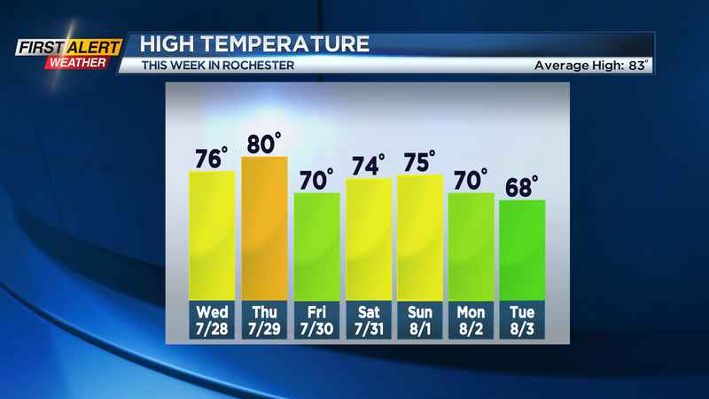
Any lingering evening storms end, and we’ll be left with lots of clouds and some lingering showers tonight into Wednesday morning. Drier air pushes in from the north, bringing us more sunshine by the afternoon, along with cooler but comfortable air.
We’ll see another round of showers and some storms moving in on Thursday. After a dry start with some sun, we’ll turn our attention toward the afternoon with a renewed chance for some thunder. Once again, while it isn’t a guarantee, any storm that does develop Thursday may produce some gusty wind.
Much like Wednesday, Friday will start off with clouds and lingering showers but should clear during the afternoon.
The weekend: We’ll round out the last day of July on a calm and dry note, with a partly cloudy sky and comfortable temperatures in the 70s on Saturday. Sunday will feature a better chance for more showers as another system zips by. This will set the stage for a cool start to August, with highs in the lower 70s through the middle of next week, but also a much drier pattern will be setting up.
Our next rain chance after this weekend may not come until the end of next week. Many will welcome this break in the active weather, and give us a chance to spend some quality time outdoors!
——————————
Download the WHEC First Alert Weather app to stay up to date while on the go.
Watch the latest full forecast at whec.com/weather.