First Alert Weather: Looks calm and mostly dry for this week leading up to the Fourth of July
[anvplayer video=”5118369″ station=”998131″]
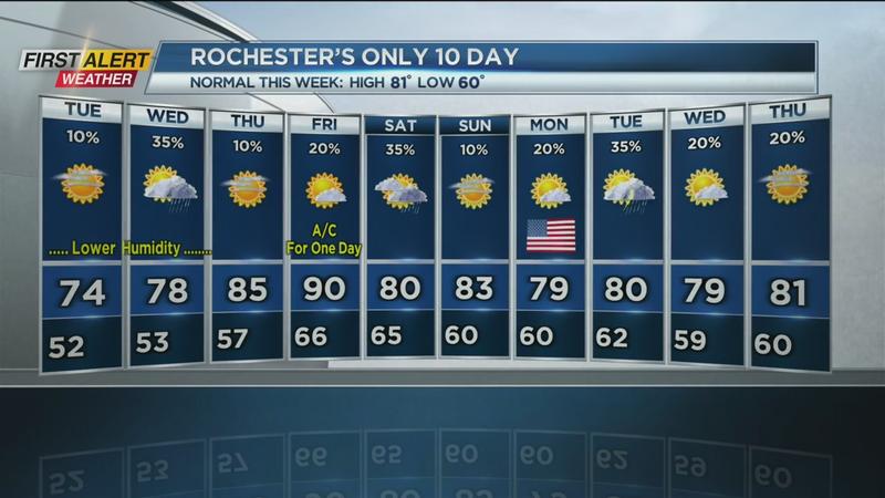
ROCHESTER, N.Y. (WHEC) – It was a refreshing breeze that returned to Western New York Monday.
Lower amounts of heat and humidity make for a very comfortable start to the week. A high-pressure system has settled in across the northeast and Ohio Valley with dry weather persisting for most of the week. The one exception could be Wednesday with just a few spotty showers possible. The second half of the week will get Rochester back to more mid-summer conditions as the heat and eventually, humidity, make a return.
Tonight look for patchy clouds to slowly give way to clearing skies. It will turn very cool for the end of June with the low temperature near 52 degrees and into the upper 40s in the deeper valleys south of Rochester. Tuesday will feature more sunshine and lower humidity. The temperature will rise into the low to middle 70s. Wednesday should be dry for most of the day, but there is the chance of a few spotty showers by the afternoon. The high temperature will be in the upper 70s.
Once we reach Thursday and Friday the heat and humidity will build into Western New York. Look for a fair amount of sunshine for both days with the mercury rising into the mid-80s on Thursday and closer to 90 degrees by Friday.
An early view of the upcoming Fourth of July Weekend appears to be tranquil and mainly dry. Look for all three days to have a temperature within a few degrees of 80 with just the chance of a lingering shower on Saturday morning.
Stay tuned to News 10 NBC First Alert for updates on the forecast.
______________
Download the WHEC First Alert Weather app to stay up to date while on the go.
Watch the latest full forecast online.