First Alert Weather: Strong storms possible tonight, and another chance later this week
[News10NBC]
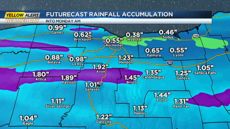
ROCHESTER, N.Y. (WHEC) — A cloudy Sunday is generally expected across the region today.
There will be a chance for a few light showers throughout the day, and the best chance for a shower will be for areas north of the Thruway as a cold front slides in from the north. Showers today will give way to a line of possibly strong storms late this evening/early tonight. A cold front will settle across our region and allow energy to move across the region with storms capable of producing strong gusty winds, small hail, heavy rain, and the chance of a brief tornado. Severe chances tonight will begin to subside after midnight and we will start the day off Monday on the cloudy side. As this front slides to our south, we will turn comfortable Monday afternoon with sunshine, but the humidity and storm chances will again move into the region for the middle of the week.
Another area of low pressure will bring showers and storms on Tuesday and Wednesday. A warm front will bring us some afternoon storms Tuesday before a cold front brings us an increased chance for showers on Wednesday. We will be watching out for the chance of strong storms on Tuesday. The Storm Prediction Center has a marginal risk up for our region and with the heat and humidity, there will be energy capable of producing strong storms. Also, models are signaling strong winds in the upper levels of the atmosphere which would help contribute to the growth of storms. Still, only a limited chance is expected, but we will monitor Tuesday along with today so make sure you follow along with the First Alert Weather team.
———————————————
Download the WHEC First Alert Weather app to stay up to date while on the go.
Watch the latest full forecast at whec.com/weather.