Soupy weather will continue to bring storm chances until relief arrives this weekend
[News10NBC]
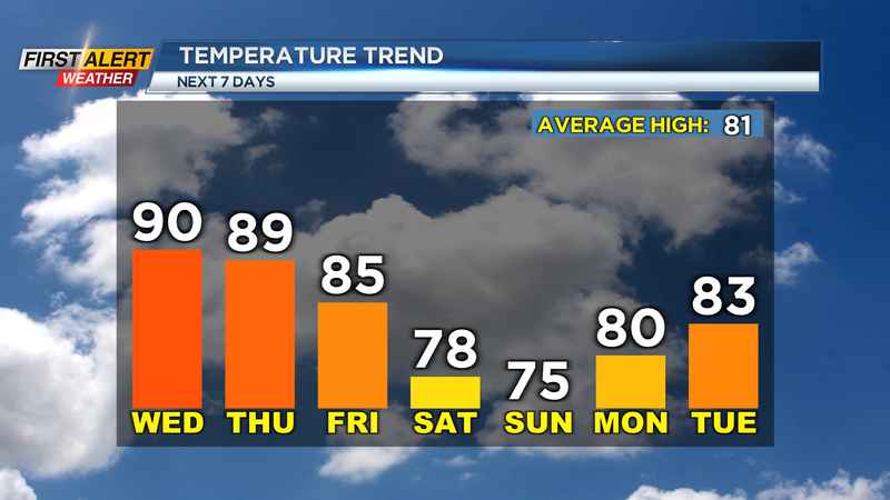
ROCHESTER, N.Y. (WHEC) — As mentioned numerous times already, the heat and humidity will continue through the rest of the week. Relief will come in the form of a cold front, but that will not come until the weekend. Temperatures will remain in the mid and upper 80s to near 90 through Friday, and it will remain muggy with dew points near 70. That moisture will also bring the chance for thunderstorms across the region until things settle down starting Saturday.
With all the thunderstorm energy in place, we could see an isolated storm over the next few days become severe warned with gusty winds and localized flash flooding as they roll through. Most of the upcoming days though will be on the dry side with partly cloudy skies.
With this cold front rolling through, we will also see a drop in temperatures as we turn more comfortable. Highs this weekend will drop into the 70s and dew points will crash into the 50s. So, this upcoming weekend we will be able to give our air conditioners a break with the cooler weather ahead.
Also towards the middle of next week, we turn a bit unsettled again as we will be tracking the moisture of Tropical Storm Fred moving into the southeast US which could bring us some rainfall locally.
The track of Fred out that far is highly uncertain at this time, but there is the potential for some tropical moisture to return locally. This will in turn bring the dew points up once again as well.
Download the WHEC First Alert Weather app to stay up to date while on the go.
Watch the latest full forecast at whec.com/weather.