First Alert Forecast: Damp, Cool and Soggy Weather to Start the Week
[anvplayer video=”5137265″ station=”998131″]
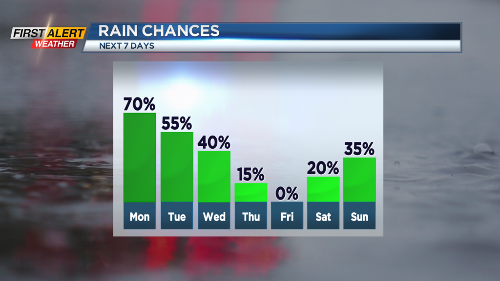
ROCHESTER, N.Y. – Even when we do get a break from the showers, it will not last very long. This is a very soggy weather pattern for the next few days. Not a continuous rainfall, but periodic showers and thunder are expected until the middle of the week. Several areas of low pressure will pinwheel across the eastern Great Lakes and New England for the next 48 hours before finally clearing Thursday. In addition, locally, progressively colder air will enhance the rain coming in off Lake Erie.
Over the next 72 hours we will find some very changeable weather. Tonight look for a few breaks in the clouds along with passing showers and maybe some thunder. The temperature will fall into the lower 50s. The News 10NBC First Alert meteorologists expect a similar forecast each day though the middle of the week. Specifically Monday, Tuesday and Wednesday will bring occasional showers and thunder. Skies may brighten from time to time. The temperature will be in the lower 60s on Monday, but then falling to near 60 on Tuesday and eventually into the middle 50s by Wednesday.
The turnaround in conditions will happen on Thursday as skies become partly sunny. However, it will remain very cool with the high temperature only in the mid-50s. Friday should feature more sunshine with the temperature rising into the lower 60s. It is expected the fair weather will continue for the start of the weekend.
In addition, we continue to watch the progression of Tropical Storm Ian. As Ian approaches the Gulf of Mexico, it will strengthen into the major hurricane in coming days. All communities from the west coast of Florida, to the Panhandle of Florida, will need to focus on watches and warnings later in the week.
Stay tuned to News 10 NBC First Alert for the latest on Ian and updates to our own local forecast.