First Alert Forecast: Yellow Alert Posted for Wednesday night and early Thursday
[anvplayer video=”5163608″ station=”998131″]
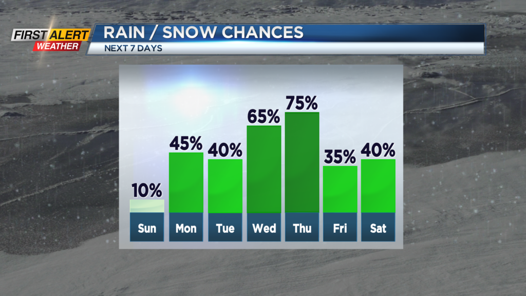
ROCHESTER, N.Y. – Calm and largely uneventful weather is expected for Western New York for the next few days. However, the News 10NBC First Alert weather team is tracking a storm for later this week which could bring a messy mix of winter precipitation to the area.
Tonight, we see clouds increasing overnight. It will not be as cold as last night with the low temperature within a few degrees of 30. Sunday will feature a mix of clouds and limited sunshine with the high temperature in the upper 40s to near 50 degrees. It should be noted that the temperature tomorrow will be some 15 degrees warmer than a typical day for the middle of February. Monday will bring gray skies with a rain or wet snow shower possible south of Rochester. It will not be as mild with the mercury in the lower 40s. Tuesday will bring another chance of a rain or wet snow shower. It will be breezy at times with the high temperature in the middle 40s.
By Wednesday and Thursday, a front will settle across the Ohio Valley with several low-pressure systems running along the front. It is likely that Rochester will be located on the colder side of the front which could be problematic for the type of precipitation. There is still a great deal of uncertainty, but it is likely there will be periods of sleet and freezing rain. At this point, the time frame for the greatest concern will be Wednesday night and early Thursday. If we see several hours of a wintry mix there is the chance of significant icing possible. As a result, the News 10NBC First Alert meteorologists have issued a yellow alert due to this increasing potential for ice accumulation. Please keep in mind that we expect many updates to the timing, intensity, and type of precipitation in the coming days.
It is recommended that you continue to check back for updates on the forecast.