First Alert Weather: Another damp and dreary day for Rochester

We’ve seen quite a change in the weather pattern compared to the mid-summer heat that we had earlier in the week.
This past Wednesday, the Rochester airport recorded a high temperature of 92 degrees, but this weekend the temperature was only within a few degrees of 70. Once again, a nearly stationary front was stretching from central Pennsylvania into southern New England which continued to funnel moisture across Western New York.
Although the rain has been much lighter and more sporadic Sunday, pockets of drizzle and light showers continue especially for communities south and east of Rochester.
Looking ahead to Monday, it appears that drier air will finally arrive bringing some sunshine back the area.
Sunday night, look for pockets of fog, drizzle, and light rain especially south and east into the Finger Lakes. The low temperature will be within a few degrees of 60.
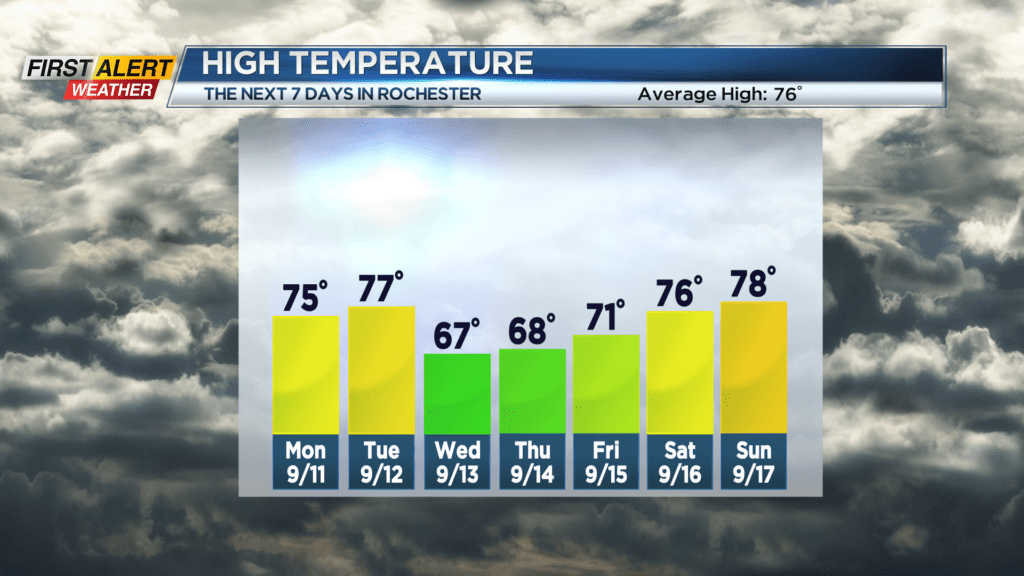
Monday, any early morning clouds will give way to partial sunshine. The mercury will rise into the middle 70s. Tuesday will bring breaks of sunshine for the morning with more clouds and thundershowers returning later in the afternoon. The high temperature should reach the mid to upper 70s. Then it will turn cooler with a spotty shower possible for Wednesday and Thursday.
Stay tuned to News 10NBC First Alert weather for updates on the forecast.