UPDATE: Red Alert Weather on Friday and Saturday for storm, school closings for Friday start to come in
A storm is expected to bring bitter cold, lake effect snow, and potentially damaging winds to the Rochester region on Friday and Saturday. News10NBC has issued a Red Alert for those two days. An Arctic cold front will start to swing through the region around 8 or 9 a.m. on Friday.
You can see updates on the storm here:
THURSDAY
School closings for Friday are coming in: Local school districts and organizations have started to announce closings for Friday in anticipation of the winter storm.
You can see a list of closings here. If you’re a school or organization that wants to post a closing on our website, you can do so here.
Mayor Malik Evans announced that all RCSD schools will be closed on Friday. They were closed on Thursday as well due to a water main break. Some other school districts that will close on Friday include Penfield CSD, Churchville-Chili, Hilton Central, and Canandaigua.
State of emergency begins (12:00 PM): The City of Rochester is under a state of emergency after a massive water main break Wednesday night – and an impending snow and wind storm rolling in Friday morning.
Local leaders spoke at the Monroe County Emergency Operations Center at a Thursday conference about the storm and the water main break. Some of the leaders who spoke were Mayor Malik Evans, County Executive Adam Bello, Department of Health Commissioner Dr. Michael Mendoza, and Environmental Services Commissioner Richard Perrin.
You can watch the full press conference here:
[anvplayer video=”5154128″ station=”998131″]
Latest forecast (12:00 PM): With the latest model guidance and update from the National Weather Service, the First Alert Weather Team has decided to upgrade to a Red Alert for Friday and Saturday.
[anvplayer video=”5154129″ station=”998131″]
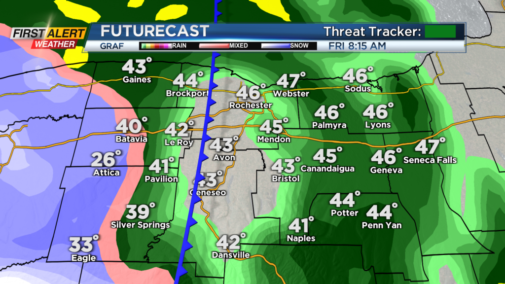
This comes as a smorgasbord of weather is headed our way, and this will likely hurt travel across our region. Late today, we will begin to see some rain showers develop from the south.
We could see a few flakes fly to start, but no issues to roadways are expected, and it will quickly turn to rain this evening. Scattered showers continue through tonight and into early tomorrow the region should be just fine.
However, the arctic cold front will swing through around 8 or 9 am on Friday and that is when things will take a downward turn. Winds will begin to pick up as the front swing through, and our temperatures will begin to crash.
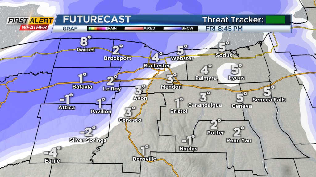
We will also see a little bit of snow on the backside and although not much accumulation is expected by the evening Friday, the gusty winds could create whiteout conditions at times.
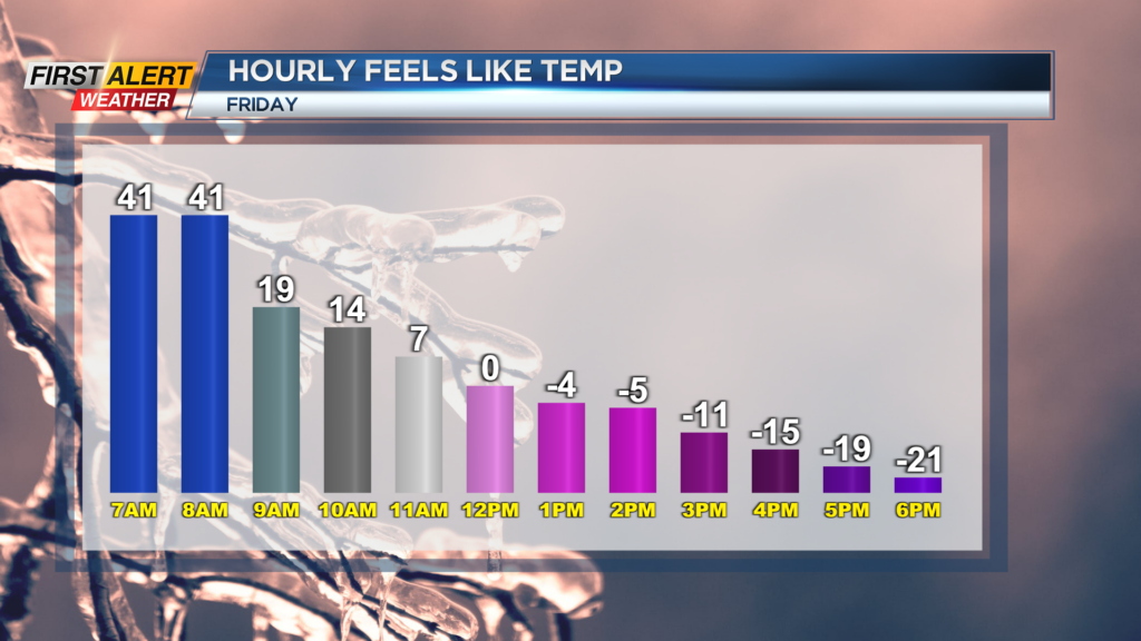
Temperatures will begin to crash as they start off in the 40s and then drop into the teens by noon and then single digits by the evening. All along with the gusty winds which will make it feel like minus 20 by Friday evening.
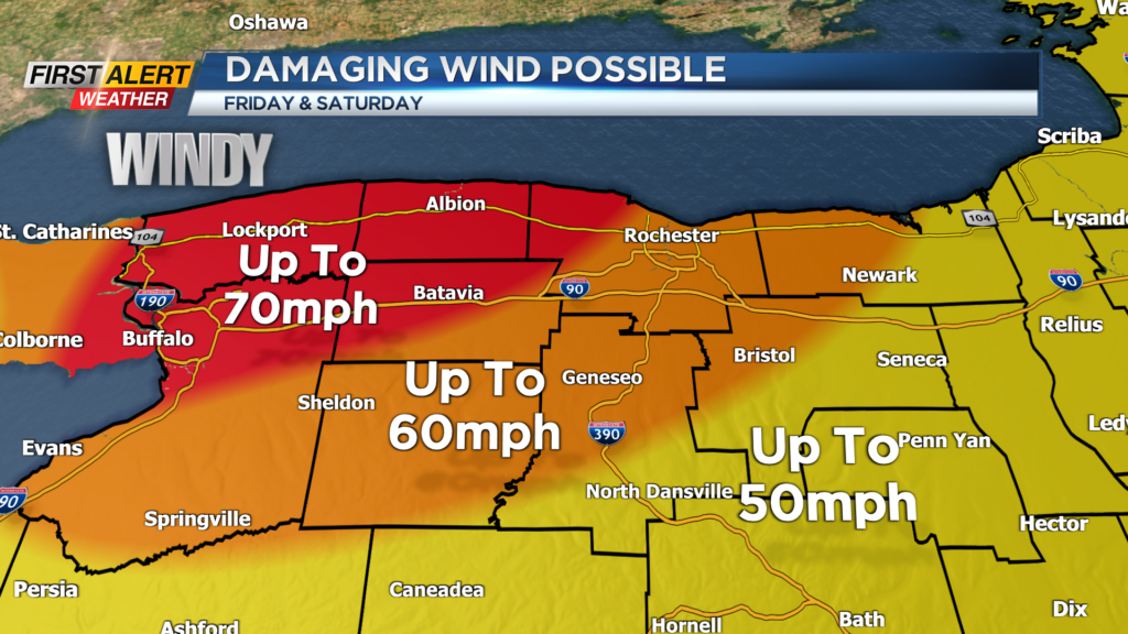
This will create that chance for a flash freeze on roadways, significantly hurting travel tomorrow. Winds will also be a major factor tomorrow and into Saturday with gusts up to 70mph areas west of Rochester with most of the area seeing gust near 60mph.
This will create an opportunity for downed trees and power lines as well as power outages. We are not done there yet.
As we head into Friday evening, lake effect snow will set up off of Lake Erie and continue through early Christmas morning.
Travel will be significantly hindered for areas west of Rochester due to the snow and wind with blizzard conditions very likely within the snow band. As far as accumulations, 1 to 3 feet is expected for folks in Buffalo with possibly close to 2 feet for Batavia northward.
Western Monroe County will also get into the action this time with near a foot of snow by Sunday morning. So with all this said, the best time to head out for Christmas plans will be sometime today.
However heading anywhere east this weekend, travel should be much better starting Saturday morning out towards Central NY. Stick with the First Alert Weather Team through the holiday weekend for updates on the weather and local power outage numbers.
______________
Download the WHEC First Alert Weather app to stay up to date while on the go.
Watch the latest full forecast online.