First Alert Weather: Today the showers were more persistent than expected
[anvplayer video=”5191632″ station=”998131″]
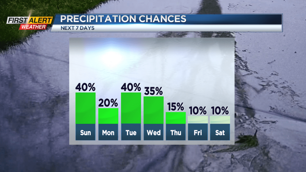
A nearly stalled front has moved very little during the last 24 hours. In fact, the front seems to have retrograded closer to Western New York for this Saturday and, as a result, more rain has been moving along the front, bringing the wet weather back into the Rochester area. Most of us had at least light showers, while communities east of the Genesee Valley even had a few downpours. Looking forward in time to Sunday, this front will move very little — which means more showers will be likely.
Tonight, look for passing showers and maybe even some thunder possible for the early evening in Finger Lakes. The temperature will fall to near 60 degrees for the overnight. Sunday will again bring more clouds with a few showers – especially for the morning. However, skies may begin to brighten by late afternoon. Most of the day will be spent in the 60s with the high temperature near 70 degrees. Monday, the front should finally begin to move more to the east of Rochester, which would allow more dry air into the area so Western New York will slowly begin to dry out. Any showers will end with skies becoming partly sunny by Monday afternoon. The high temperature should reach the middle 70s.
Stay tuned to News 10NBC First Alert Weather for updates on the forecast.