First-Alert Weather: Lake effect snow’s mostly quieted down — but areas west of Rochester can expect some
After some heavy lake effect snows across the area Saturday morning, things have quieted down Saturday evening. Accumulations ranged from a few inches south of Rochester to upwards of a half foot or more north of Routes 104 and off to the east into Wayne County. Outside of some lake snow showers and flurries this evening with temperatures in the 20s, we will be watching for more organized lake snow to develop off Lake Erie overnight as we see a wind shift back to the southwest behind a weak disturbance.
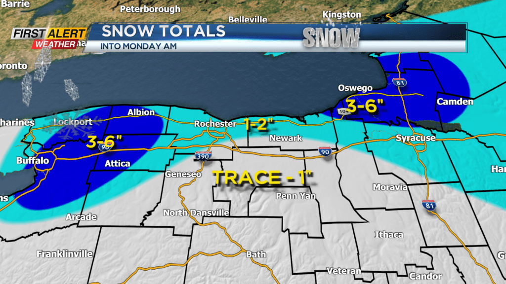
Winter Weather Advisories go into effect for Orleans and Genesee counties starting at 10 p.m. Saturday through 1 p.m. Sunday. Lake effect snow showers will continue for areas west of Rochester and then tapering into Sunday afternoon. The threat tracker will be green as most of our viewing area will not see much more than an inch or two of snow during this time. Portions of Orleans and Genesee counties could pick up 3-6 inches or more in the most persistent bands.
Any lingering lake snow showers and flurries taper Sunday night into Monday. It’s looking relatively quiet heading into the first half of next week with milder temperatures returning.